
TL;DR:
- Exploration budgets have increased, but discovery efficiency for copper and gold has declined globally.
- AI and machine learning models significantly outperform traditional methods in ranking mineral targets and improving prospecting efficiency.
- High-quality geospatial data and remote sensing are critical for successful prospecting in complex terrains like NSW and Victoria.
Exploration budgets have ballooned over the past two decades, yet exploration spend doubled since 2005 while discovery efficiency for copper and gold has actually declined globally. That's not a technology failure. It's a strategy failure. Prospectors and mining teams in New South Wales and Victoria are sitting on some of the world's most mineralized terrain, but throwing more money and more tools at a problem doesn't automatically produce more finds. Prospecting efficiency, meaning the ratio of valuable discoveries made per dollar and hour invested, is the real metric that separates successful operations from expensive dead ends. This article breaks down exactly what drives it and how to improve it fast.
Table of Contents
- Defining prospecting efficiency in mineral exploration
- Traditional vs AI/ML-driven prospecting: A performance comparison
- Unlocking site success with geospatial data and remote sensing
- Measuring and boosting your prospecting efficiency: Practical frameworks
- The uncomfortable truth about prospecting efficiency in 2026
- Ready to elevate your prospecting efficiency?
- Frequently asked questions
Key Takeaways
| Point | Details |
|---|---|
| Efficiency metrics matter | Track implied probability, discovery rates, and prediction model scores to gauge prospecting success. |
| Blend AI with local expertise | Combine advanced models with traditional field knowledge for the biggest discovery wins. |
| Validate with real outcomes | Always check AI predictions against on-the-ground results to avoid costly errors. |
| Data drives efficiency | Leverage remote sensing, geospatial, and geochemical data to target high-potential sites. |
Defining prospecting efficiency in mineral exploration
Prospecting efficiency isn't just a vague concept about working smarter. It has real, measurable definitions used by geologists and exploration scientists worldwide. At its core, efficiency measures how well your exploration effort converts into actual mineral discoveries.
From a scientific standpoint, efficiency is measured using three primary metrics: implied probability of discovery (the statistical likelihood a targeted area contains a deposit), discovery rates (how many new deposits are found per unit of exploration effort), and prediction model performance scores such as AUC-ROC curves (a value between 0.5 and 1.0 that reflects how well a model separates mineralized from barren ground). An AUC-ROC of 0.9 or above is considered strong. Below 0.7 and your model is barely better than guessing.
"The gap between model accuracy and field discovery success is where most exploration budgets go to die." This is the reality facing teams who optimize for data metrics without closing the loop with ground truth.
Declining efficiency in copper and gold is not just a global headline. It has direct implications for NSW and Victoria, where near-surface deposits are increasingly exhausted and new finds require targeting concealed or deep mineralization. That demands better models, not just more drilling.
Several factors shape efficiency in the field:
- Deposit depth: Deeper targets require more expensive detection methods and carry higher uncertainty
- Data quality: Sparse or outdated geochemical and geophysical datasets degrade model reliability
- Team expertise: Experienced geologists interpret ambiguous signals that algorithms miss
- Technology fit: Using a sophisticated AI model on a thin dataset is like running a sports car on gravel
- Validation practice: Models validated only on training data, not real discovery outcomes, give false confidence
| Metric | What it measures | Typical use case |
|---|---|---|
| Implied probability of discovery | Likelihood of deposit per target area | Regional target ranking |
| Discovery rate | Finds per exploration dollar or drill hole | Budget optimization |
| AUC-ROC score | Model discrimination ability | Prospectivity model benchmarking |
| Prediction-area curve | Coverage vs. accuracy tradeoff | Validation and field planning |
Understanding alluvial gold detection methods in the context of these metrics helps teams in Victoria and NSW prioritize field effort where the probability of discovery is genuinely high, not just where the terrain looks promising.
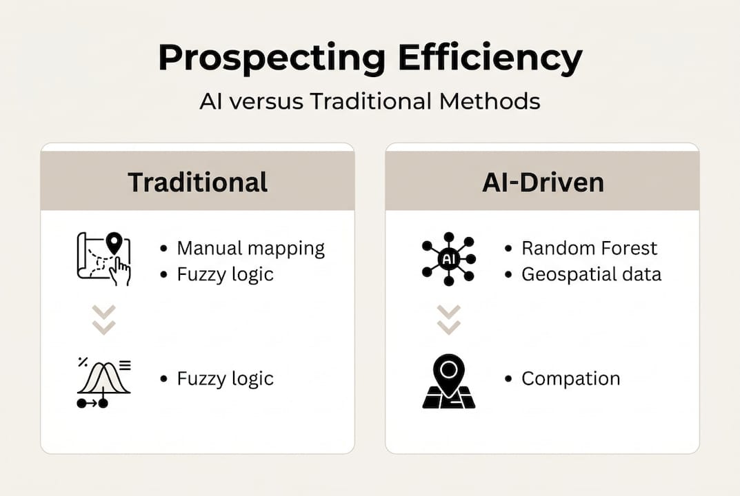
Traditional vs AI/ML-driven prospecting: A performance comparison
Classical prospecting methods fall into three broad categories. Knowledge-driven models rely on expert geologists interpreting mineral system frameworks. Data-driven models use deposit statistics and geochemical patterns. Hybrid approaches combine both, typically using GIS overlays and manual weighting. Each has strengths, but all share a common ceiling: human cognitive bandwidth.
Modern AI and machine learning (ML) models break that ceiling. Random Forest (RF) is an ensemble method that builds hundreds of decision trees and averages their outputs, handling noisy datasets well. Convolutional Neural Networks (CNNs) excel at pattern recognition in spatial and image data, making them ideal for remote sensing analysis. Deep Forest is a newer architecture that performs well even with limited training samples, which matters enormously in regions where historical drill data is sparse.
The performance gap is significant. AI/ML models like RF achieve AUC-ROC scores of 0.949 compared to traditional Fuzzy Logic models scoring 0.806 on the same datasets. That's not a marginal improvement. It's the difference between targeting the right 10% of a region versus wasting resources across 30%.
Pro Tip: Match your model's complexity to your data volume. Running a deep learning CNN on fewer than 50 known deposit locations will overfit and produce unreliable predictions. Random Forest or logistic regression performs more reliably with sparse training data.
When to stick with classical approaches:
- You have fewer than 30 known mineral occurrences to train on
- Your geophysical data coverage is patchy or outdated
- Budget constraints limit computational resources
- Local expert knowledge is unusually strong and well-documented
When to switch to AI/ML:
- Multi-layer geospatial datasets are available (geochemistry, magnetics, gravity, remote sensing)
- You need to rank hundreds of targets quickly
- Discovery rates from traditional methods have plateaued
- You're targeting concealed or deep deposits in complex terrain
Exploring AI prospecting tools built for NSW and Victoria gives you a practical entry point without needing a data science team in-house. Understanding the role of geodata in feeding these models is equally critical. Teams that invest in AI prospecting for higher efficiency consistently report faster target turnaround and lower cost per discovery.
Unlocking site success with geospatial data and remote sensing
Geospatial data is the fuel that powers every modern prospecting model. Without high-quality, current spatial datasets, even the best AI algorithms produce noise. In NSW and Victoria, the combination of GIS platforms, airborne geophysics, and satellite remote sensing has transformed what's detectable from the surface.
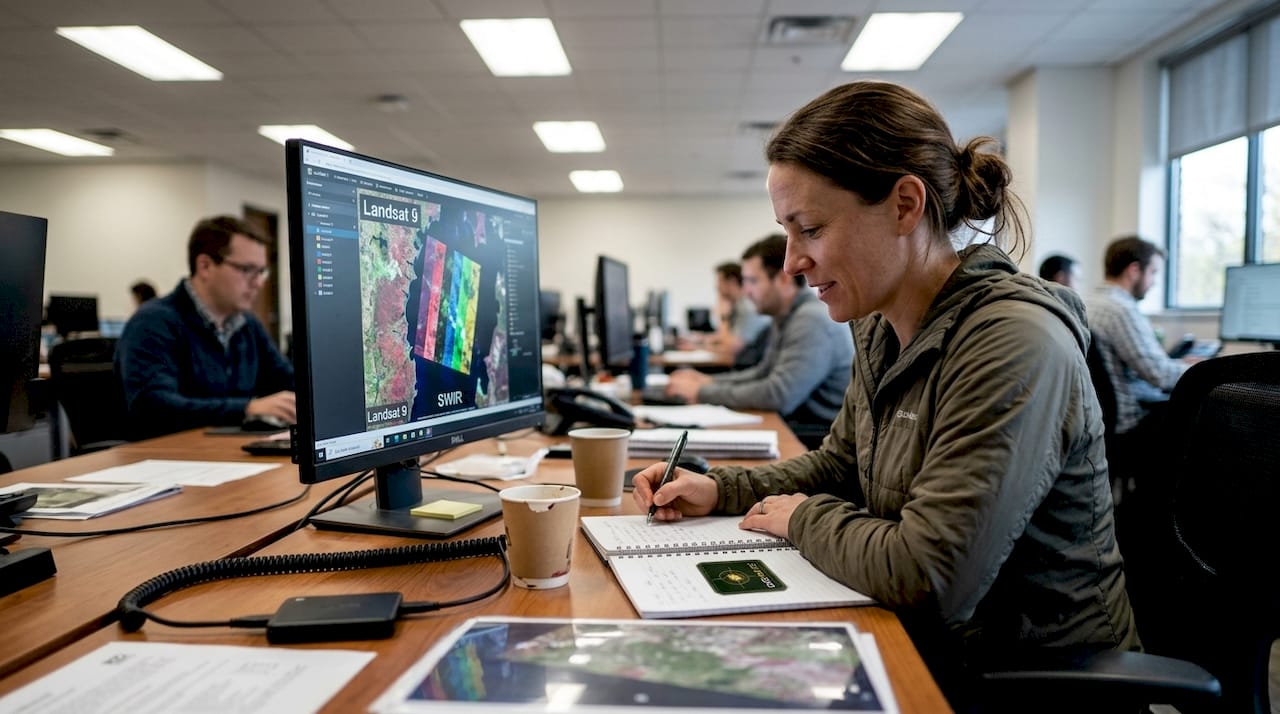
Remote sensing satellites like Landsat 9 and Sentinel-2 capture multispectral and shortwave infrared (SWIR) imagery that reveals hydrothermal alteration zones, iron oxide concentrations, and clay mineral distributions. These are all indicators of potential mineralization. CNN models using Landsat 9 outperform traditional classifiers like KNN, SVM, and MLP for iron oxide mapping, and Landsat 9 outperforms Landsat 8 in the same tasks due to improved band calibration.
Pro Tip: Always validate your remote sensing alteration maps with at least a few ground truth samples before committing to a drill program. A spectral anomaly that looks like hydrothermal alteration can sometimes be laterite weathering or agricultural soil disturbance.
The most valuable datasets for prospectors operating in NSW and Victoria include:
- Landsat 9 and Sentinel-2 imagery: For alteration mapping and land cover classification
- Geoscience Australia airborne magnetics: Reveals structural controls and intrusive bodies at depth
- ASTER multispectral data: Excellent for clay mineral and carbonate mapping in epithermal systems
- State geological survey geochemistry: Soil, stream sediment, and rock chip data for anomaly detection
- Digital elevation models (DEMs): Critical for drainage analysis and alluvial target identification
Geoscience Australia's regional geophysical surveys and state geological maps remain foundational inputs. No AI model should run without them as base layers.
Using advanced site selection tools that integrate these datasets removes the manual bottleneck of cross-referencing multiple data portals. The importance of geodata cannot be overstated when targeting concealed deposits. For teams evaluating platform options, reviewing remote sensing alternatives helps identify which tools best fit NSW and Victoria workflows.
Measuring and boosting your prospecting efficiency: Practical frameworks
Knowing your AUC-ROC score is a start. But efficiency gains only materialize when you close the loop between model predictions and real-world discovery outcomes. Most teams skip this step and wonder why their models keep missing.
Prospectivity models must validate using efficiency curves, specifically success-rate curves (what percentage of known deposits fall within your predicted high-priority zones) and prediction-area curves (what percentage of total area those zones cover). A model that captures 80% of known deposits in just 20% of the study area is genuinely useful. One that needs 60% of the area to capture 80% of deposits is expensive to act on.
Here's a practical four-step framework for improving efficiency in any prospecting workflow:
- Select your model and data stack: Match AI complexity to available training data. Use RF or Deep Forest for sparse datasets. Reserve CNNs for image-rich, multi-band remote sensing tasks.
- Run prospectivity mapping: Generate ranked target maps with probability scores. Overlay structural, geochemical, and geophysical layers for multi-criteria analysis.
- Validate with discovery outcomes: Compare predictions against known mineral occurrences and recent drill results. Calculate your success-rate and prediction-area curves. If the model underperforms, identify which data layer is weakest.
- Iterate for efficiency gains: Adjust input data, model parameters, or training samples based on validation feedback. Each cycle should improve your discovery rate per dollar spent.
This loop applies equally to alluvial gold detection frameworks in Victoria's goldfields and hard-rock copper targets in NSW. The principle is identical: measure, validate, improve.
Cost reduction follows naturally. When your model reliably ranks targets, you drill fewer dry holes. Teams that implement this validation cycle consistently report 20 to 40 percent reductions in cost per discovery over two to three exploration seasons.
The uncomfortable truth about prospecting efficiency in 2026
Here's what most technology vendors won't tell you: a perfect AUC-ROC score on paper has never put gold in a pan. We've seen teams in NSW and Victoria invest heavily in state-of-the-art AI platforms, generate beautiful prospectivity maps, and then drill nothing but barren rock because they trusted the model over the geologist standing on the outcrop.
AI is a force multiplier, not an autopilot. The regions where we see the highest-impact discoveries aren't the ones with the most sophisticated algorithms. They're the ones where experienced prospectors use AI to confirm and sharpen their instincts, not replace them. Complex terrain like the Lachlan Fold Belt or the Victorian goldfields has structural subtleties that no training dataset fully captures.
Chasing model perfection also creates a dangerous delay loop. Teams spend months refining parameters instead of getting boots on the ground. The best regional prospecting strategy we've observed blends AI-generated target rankings with local geological knowledge, then validates fast with low-cost field reconnaissance before committing to expensive drilling. That's the real efficiency unlock in 2026.
Ready to elevate your prospecting efficiency?
Putting these frameworks into practice requires the right platform behind you. Digmate App brings together AI-driven mineral detection, geospatial mapping, and site analysis tools built specifically for prospectors and mining professionals working across New South Wales and Victoria.
Whether you're ranking targets with prospectivity models, validating remote sensing anomalies, or optimizing your field program for cost efficiency, the DIGMATE platform gives you the data and tools to act with confidence. Stop guessing and start discovering with AI and geodata working together in your corner.
Frequently asked questions
What is prospecting efficiency and how is it measured?
Prospecting efficiency reflects how effectively exploration investments yield new mineral discoveries, commonly measured using discovery rates, implied probability of discovery, or prediction model performance scores such as AUC-ROC.
How do AI and machine learning improve mineral prospecting in NSW and Victoria?
AI and ML models outperform traditional detection methods by identifying hidden mineralization patterns across large geospatial datasets, especially when validated with local geological knowledge from NSW and Victoria.
What type of data is most valuable for efficient prospecting?
Geospatial datasets from remote sensing and geospatial data sources like Landsat 9 and Sentinel-2, combined with geochemistry and geophysics, deliver the strongest inputs for AI-driven prospectivity mapping in NSW and Victoria.
Why is prospecting efficiency declining despite more advanced technologies?
Global exploration efficiency is declining because most new technologies are not validated against real field outcomes, and increasingly deep or concealed deposits require more than improved algorithms to reliably detect.