
TL;DR:
- Successful gold prospecting relies on combining official geospatial data with modern GIS tools.
- Ground truthing and geological analysis significantly improve site selection and detection efficiency.
- Most prospectors overlook profitable deposits by relying on outdated information and skipping data analysis.
Plenty of prospectors in New South Wales and Victoria spend weekends digging at overworked sites they found on a Facebook group, only to walk away empty-handed. Outdated paper maps and forum tips from five years ago rarely lead to productive ground. The reality is that gold prospecting success rates climb sharply when you combine official geospatial datasets, modern GIS tools, and systematic fieldwork. This guide walks you through every practical step, from securing permits and sourcing geological data to executing a smart site selection process and avoiding the mistakes that cost most prospectors their best opportunities.
Table of Contents
- Know your prerequisites: research, permissions, and tools
- Use modern data: geospatial datasets and geological maps
- Smart site selection: tech, geospatial analysis, and ground truthing
- From detection to discovery: tools, tactics, and avoiding common mistakes
- Why most prospectors overlook profitable deposits
- Ready to find more gold in NSW and Victoria?
- Frequently asked questions
Key Takeaways
| Point | Details |
|---|---|
| Official data is essential | Accessing up-to-date geological datasets increases your chance of finding gold sites. |
| Tech accelerates success | GIS, remote sensing, and the right detection tools dramatically improve prospecting outcomes. |
| Legal preparation matters | Always research and follow local regulations to avoid problems and fines. |
| Ground truthing is critical | Validating sites on the ground confirms real prospects behind the digital data. |
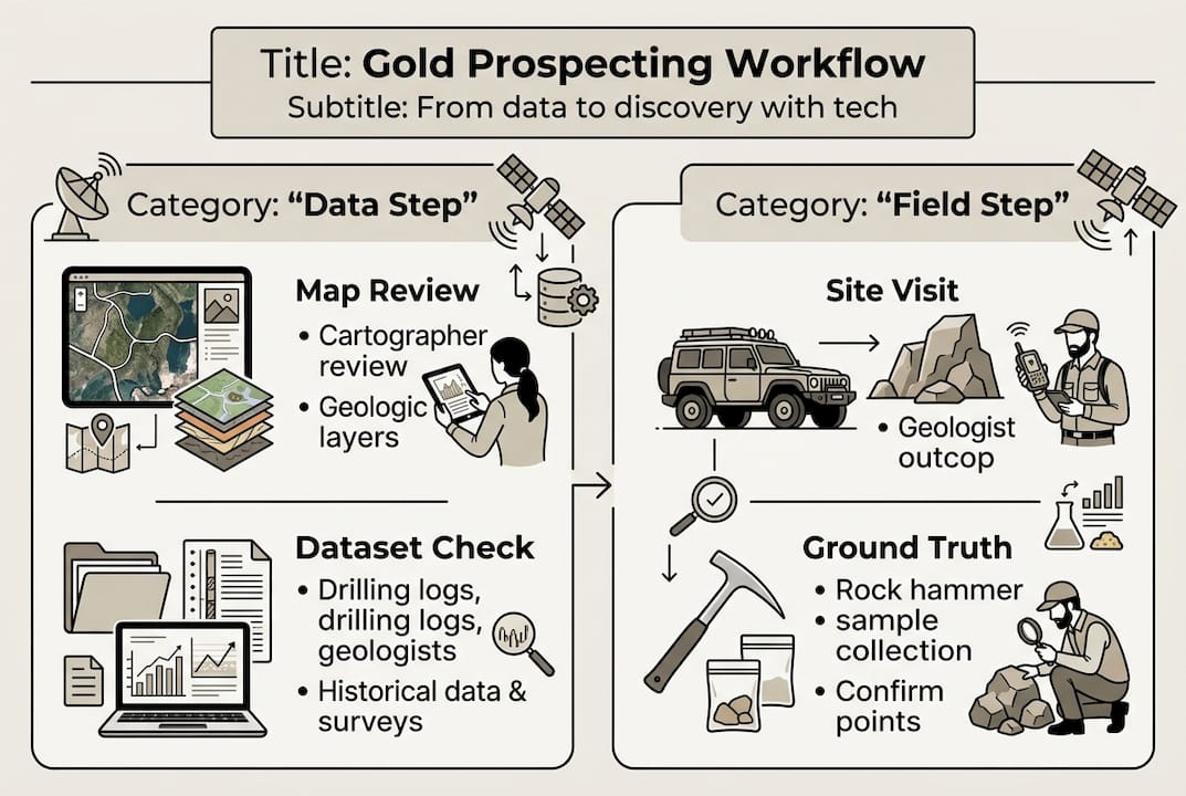
Know your prerequisites: research, permissions, and tools
Before you pack the truck, you need to sort out three things: legal access, the right equipment, and the right data. Skipping any one of them will waste your time or, worse, land you in legal trouble.
In both NSW and Victoria, prospecting on public land requires a valid miner's right or fossicking license, depending on the activity. Private land needs the landowner's written permission. National parks and Aboriginal heritage sites are off-limits entirely. Check with the NSW Resources Regulator and the Victorian Department of Energy, Environment and Climate Action before you commit to any location.
For equipment, the standard kit has expanded significantly in recent years. The required prospecting tools now go well beyond a metal detector and a pan. Here is what a well-prepared prospector carries:
- A high-frequency metal detector tuned for small gold (14 kHz or higher)
- A GPS unit with topographic overlays
- A tablet or phone loaded with a GIS app
- Sluice or dry blower depending on water availability
- Sample bags, a loupe, and a field notebook
The comparison below shows how traditional methods stack up against a modern data-driven approach:
| Factor | Traditional approach | Modern tech approach |
|---|---|---|
| Site identification | Forum tips, old maps | GIS overlays, official datasets |
| Target accuracy | Low | High |
| Legal compliance | Often overlooked | Built into workflow |
| Time to first find | Unpredictable | Significantly reduced |
| Repeat visit value | Diminishing | Improves with each data layer |
For data, the NSW Mineral Occurrences dataset gives you access to historical gold site records and geological data from the Geological Survey of NSW, making it far easier to identify areas with proven mineral potential before you drive out.
Pro Tip: Download offline copies of your target area's geological maps before heading into the field. Mobile data is unreliable in most goldfield regions of both states.
Use modern data: geospatial datasets and geological maps
Now that you have the essentials sorted, shifting your focus to powerful datasets is where real site selection begins. Raw data is what separates a prospector who finds gold consistently from one who relies on luck.
The NSW gold dataset is publicly available and lists historical occurrences, assay results, and mine locations going back to the 19th century. Victoria's equivalent resource is GeoVic, run by the Geological Survey of Victoria, which offers stratigraphic drill hole data, geochemical surveys, and mine records. Both are free.
Here is how to use geological maps effectively once you have the data:
- Identify favorable rock types. Gold in eastern Australia is most often found in Ordovician and Silurian metasediments, particularly slates and phyllites near intrusive granites. Flag these zones on your map first.
- Trace fault lines and shear zones. Gold deposits concentrate where fluids moved through structural weaknesses in the rock. Shear zones are your best friends.
- Overlay historical workings. If miners operated at a location in the 1860s, fluid pathways existed. Those pathways do not disappear.
- Add recent geochemical anomalies. Both NSW and Victorian surveys publish stream sediment data that highlights catchments with elevated gold values.
- Cross-reference satellite imagery. Iron oxide staining and vegetation anomalies visible on satellite can indicate buried mineralization.
The table below summarizes the key datasets and what each one tells you:
| Dataset | State | Key data type | Best use |
|---|---|---|---|
| NSW Mineral Occurrences | NSW | Historical sites, geology | Initial screening |
| GeoVic | Victoria | Drill holes, geochemistry | Deep targeting |
| SEED Portal | NSW | Open spatial data | GIS integration |
| Geoscience Australia | Both | Regional geology | Structural context |
Understanding the geological drivers of gold deposits helps you read these datasets with confidence rather than just treating them as a list of map pins.

Pro Tip: In Victoria's goldfields, trace creek systems upstream from known historical workings. Alluvial gold follows drainage patterns, and upstream sources are often untouched.
Smart site selection: tech, geospatial analysis, and ground truthing
Once data points to a promising area, the next job is narrowing it down to a specific patch of ground worth swinging a detector over. This is where GIS analysis and on-ground validation work together.
Follow this process for structured site selection:
- Load your datasets into a GIS platform such as QGIS (free) or ArcGIS. Overlay historical workings, fault lines, lithology, and stream sediment anomalies in a single view.
- Define a priority polygon. Where three or more favorable indicators overlap, that area becomes your primary target.
- Check land tenure. Use the NSW Crown Land viewer or VicPlan to confirm the parcel is accessible under your license.
- Run a remote sensing check. Multispectral satellite imagery can reveal iron-rich soils and quartz veining not visible to the naked eye.
- Visit the site before detecting. Walk the ground, note exposed rock outcrops, locate drainage lines, and check for historic diggings.
Ground truthing is non-negotiable. GIS and remote sensing combined with field validation is especially effective for orogenic and nugget gold in NSW and Victoria, but it requires solid local knowledge of regulations to be applied correctly.
The best prospectors treat ground truthing as a form of quality control. Data tells you where to look. Your boots tell you whether the data is right.
On the ground, check for these indicators:
- Quartz veins cutting through darker host rock
- Iron-stained soils (gossans), which indicate oxidized sulfides
- Old pits, mullock heaps, or hand-stacked stone walls from historical workings
- Changes in vegetation density, which sometimes indicate soil chemistry shifts
The prospecting site selection tools available today make this process far more systematic than it was even five years ago. Pair that with AI ground scan technology to add another layer of subsurface insight before you start detecting.
Pro Tip: Photograph every outcrop and soil change during your ground truthing walk. Comparing photos across visits reveals subtle changes that point toward productive zones.
From detection to discovery: tools, tactics, and avoiding common mistakes
With a site chosen and validated, field execution becomes the deciding factor. Good data and a poor detecting technique still produce nothing.
Systematic detecting means covering ground in overlapping parallel passes, keeping the coil level and close to the surface. Most beginners sweep too fast. Slow down to 1 to 2 meters per second maximum. Target signals should be checked from multiple angles before digging.
For panning or sluicing, work upstream and downstream of the area your detector flags. Gold moves in water and concentrates at natural traps: bedrock crevices, the downstream side of large boulders, and inside bends in creek channels.
Common field mistakes that cost prospectors good finds:
- Overreliance on a single indicator. A quartz vein alone does not confirm gold. Stack multiple indicators before committing to a zone.
- Poor ground contact. Coil lift, caused by swinging too high, reduces detection depth by up to 30%. Keep it close.
- Ignoring small signals. Many nuggets produce faint responses. Dig every signal in a high-priority zone.
- Skipping bedrock. Expose and check bedrock cracks in creek beds. These are natural gold traps that dry blowing misses entirely.
- No systematic grid. Wandering without a pattern means double-covering some areas and leaving others untouched.
Effective metal detector prospecting requires consistent technique combined with the right frequency settings for your target ground. The advanced exploration tips that separate successful prospectors from frustrated ones usually come down to discipline and process.
For legal handling of finds, record the GPS coordinates of each find, note the depth and orientation, and photograph in situ before removal. This data is valuable for understanding the deposit structure and planning return visits. GIS-combined remote sensing methods reinforce why documentation and pattern recognition on site elevate your results over time.
Pro Tip: Carry a small handheld GPS and mark every find, even small ones. Over multiple visits, your find pattern will reveal the orientation of the gold-bearing zone.
Why most prospectors overlook profitable deposits
Here is an uncomfortable observation: the majority of prospectors in NSW and Victoria are competing for the same worn-out ground because they all read the same forums. Those sites have been detected hundreds of times. The gold that was easy to find is long gone.
The real opportunity sits in areas that require effort to identify. That means pulling actual geological data, cross-referencing it with land tenure maps, and doing the ground truthing work before anyone else does. It is not glamorous preparation, but it is what works.
The site selection mistakes most people make come down to one thing: skipping the data step and going straight to the field. A data-first workflow does not guarantee a find, but it dramatically improves the probability and keeps you on the right side of the law at the same time. Combining modern technology with regulatory knowledge is not just about efficiency. It is about protecting your ability to keep prospecting legally and profitably for years to come.
Ready to find more gold in NSW and Victoria?
You now have a solid workflow: source the right data, analyze it spatially, validate on the ground, and execute with discipline in the field. The next step is putting that workflow into action with tools built specifically for Australian prospectors.
DigMate brings together AI-driven site analysis, up-to-date regional mapping, and geospatial insights designed for NSW and Victoria. Instead of spending hours downloading and layering datasets manually, the DigMate AI features do the heavy lifting so you can focus on the field. Start by grabbing a free gold map to see high-potential zones in your target region. Then explore everything DigMate offers to turn data into discoveries faster.
Frequently asked questions
What is the best technology for finding gold deposits in NSW and Victoria?
Combining GIS mapping, remote sensing, and advanced metal detectors gives the highest chance of success, especially when backed by local geological data specific to orogenic and alluvial gold environments in both states.
Is it legal to prospect for gold everywhere in NSW and Victoria?
No, you must secure the correct permits such as a miner's right or fossicking license, and avoid protected, private, or heritage-listed land before you start work in any location.
How do I use the NSW Mineral Occurrences dataset for gold prospecting?
The NSW Mineral Occurrences dataset lets you filter historical gold sites and geological records so you can target regions where past activity and favorable geology align with current prospecting potential.
What are the most common mistakes prospectors make when searching for gold?
Most prospectors skip official datasets, rely on crowdsourced forum tips, and ignore ground validation, which together make it far harder to locate productive ground consistently.